And just like that, we are more than one-third of the way through meteorological winter.
While astronomical winter begins about Dec. 21, meteorological winter always starts Dec. 1 and wraps up at the end of February.
Without wanting to jinx things, I have to say that we’re off to a pretty smooth start. Sometimes, the finish can look very different.
A developing La Niña will be one of the key drivers of our winter pattern. It’s not developing quickly and that's why our boots stayed in the closet through most of December.
La Niña winters tend to have some common characteristics and there is a lot of variability in exactly what this could mean for each part of Canada.
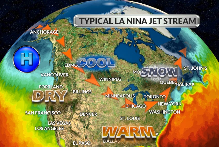
La Niña winters do tend to be colder and snowier across Western Canada, and we are starting to see that typical pattern again this winter. For British Columbia and a large part of the Prairies, we expect colder than normal temperatures with an abundance of snow across the region, including the ski areas.
Closer to home:
Here in Atlantic Canada, I expect that temperatures for the winter as a whole will be warmer than normal. This should mean fewer and shorter outbreaks of severe cold.
It’s important to keep in mind that mild doesn’t rule out significant snow or even ice storms; temperatures can be above seasonal and still cold enough for substantial snow and ice.
When we look back in history at previous La Niña winters across Eastern Canada, we see they can be memorable either for their lack of winter weather or for their abundance of winter weather.
Here is why: During La Niña winters, the jet stream typically stretches from the lower Great Lakes across to northern New Brunswick then on the Newfoundland's Northern Peninsula. With this weather set-up, moisture-laden storms are more likely to track inland with frequent snow events occurring across the region. Our last big La Niña years were 2016 and 2017. Need I say more?
- Want more weather information? Visit your weather page.
- Have a weather question, photo or drawing to share with Cindy Day? Email [email protected]
Cindy Day is the chief meteorologist for SaltWire Network