I've been watching Teddy since Monday and with each passing day, my biggest fears inch closer to reality: Teddy could be another Juan.
There are a few differences, but many eerie similarities.
Location:
Juan stayed out over open water, with no land to inhibit its powerful rotation.
Teddy has been churching out over the open Atlantic for a week now with only tiny Bermuda in its path to our coast.
Water temperatures:
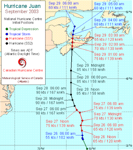
Juan: Sea surface temperatures were about 4° degrees warmer than normal when the Category 2 storm approached the coast. It is argued that these warmer SSTs made a significant contribution to this rare Category 2 hurricane at landfall in Nova Scotia.
Teddy: Right now, our offshore sea surface temperatures are almost 5° above normal.
Strength:
Hurricane Juan entered Canadian waters as a Category 2 hurricane.
Based on some computer models, Teddy could also enter Canadian waters as a Category 2 hurricane.
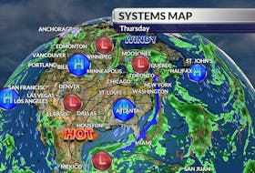
Systems on the map:
I was working for Global in 2003 and have many vivid memories of the days leading up to Hurricane Juan. I can't help but notice how similar the systems are setting up on the surface map: a strong area of high off the east coast of Newfoundland ridging back to another high-pressure system over the lower Great Lakes.

Too early to call?
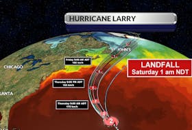
It is still early and a bit unnerving to pinpoint landfall, but my early projection is mid-day Tuesday, somewhere along Nova Scotia's central coastline – likely not too far from Halifax.
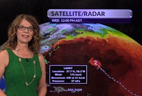
It is very important to remember that with a storm this size, more than 60 hours and 1000 km away, things can change.
I’m not writing this to scare anyone but to remind everyone of the power of a storm like Juan. Juan claimed the lives of eight individuals: two when trees fell on their motor vehicle, two fishermen near Anticosti Island, three in a house fire - speculated to have been started by candles used during the power outage, and one involved in relief work weeks after the storm.
We did learn some valuable and very painful lessons from Juan; may they not be in vain. Prepare now. I pray the storm misses us.
- Want more weather information? Visit your weather page.
- Have a weather question, photo or drawing to share with Cindy Day? Email [email protected]
Cindy Day is the chief meteorologist for SaltWire Network