CHARLOTTETOWN, P.E.I. — Tropical storm Isaias is going to make P.E.I. feel extra tropical today, says the chief meteorologist for the SaltWire Network.
During a media briefing on Tuesday, Cindy Day said this fast-moving tropical storm is in the process of transitioning into an extra tropical system.
“By the time it starts to impact any weather in Ontario, Quebec and in the western regions of the Maritimes, it will be extra tropical,’’ Day said. “That just means the warmer core has shifted so instead of it being just a closed cyclone it becomes a low-pressure system with a warm front and a cold front.’’
Northwestern New Brunswick will see about 10 to 15 millimetres of rain, but P.E.I. won’t see much, if any, moisture.
“(There) may be a few showers (Wednesday) on the tip of the warm front. Then the cold front goes through Wednesday night and the wind direction changes and it doesn’t feel quite as tropical. (But, on Wednesday) it will feel like you’re waking up in South Florida in the middle of summer. (P.E.I. will have) that tropical feel.’’
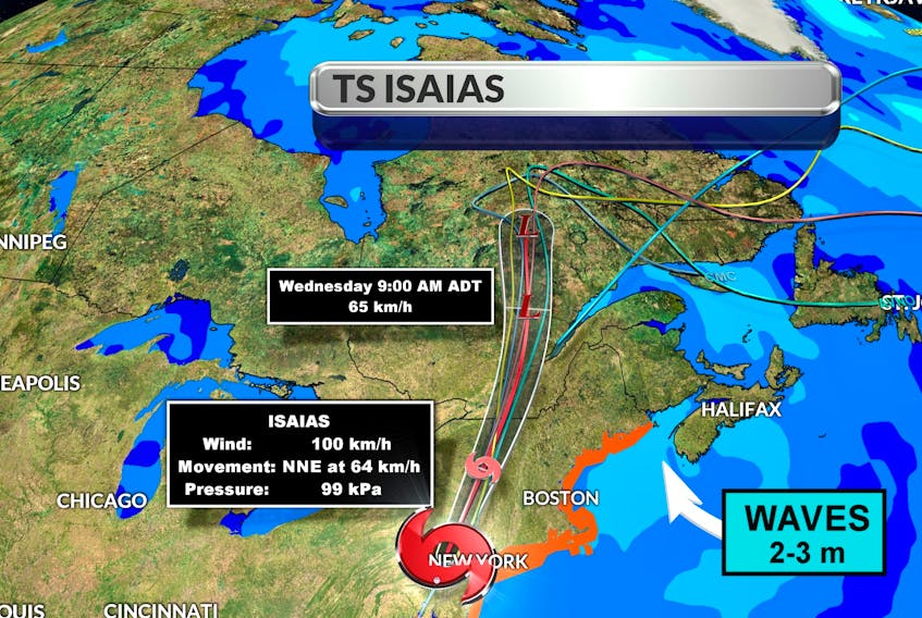
Day said western P.E.I. may see some wind gusts out of the southeast in the 50 to 60 km/h range today as a result of the system.
As for storm surge or swells, Day said there might be a bit of a sea swell along the southshore of Nova Scotia or in the mouth of the Bay of Fundy, perhaps two- to three-metre waves, but nothing to note in the Northumberland Strait or Gulf of St. Lawrence.
“We really get off quite easily with the track of this system because of the blocking Bermuda high.’’
The Bermuda high is a perennial system, and its position dictates where a tropical system will track. It is currently located close to the coast of the Maritimes and is essentially blocking Isaias from coming in, pushing it off to the west.
However, Day said clockwise flow around the high pressure system and the counter-clockwise flow around the low-pressure system will pull in some very moist air across the region.
That’s the reason for the continued heat warnings for southern New Brunswick, all of P.E.I. and western regions of Nova Scotia.
Day said the trailing cold front will brief some relief to those tropical temperatures tonight and into Thursday. However, steamy temperatures are expected to return by this weekend, she said.
“I don’t see much change in the jet stream until the middle part of September. We’re going to stay above normal (temperatures), not quite this hot, through to the middle part of September.’’
While the Maritimes don’t have to worry about Isaias, Day said the sea surface temperatures off the coast of North Carolina and the eastern seaboard mean are above average so “we could see some action pretty quickly’’.
Tropical storm Isaias to miss P.E.I., says SaltWire Network chief meteorologist Cindy Day
STORY CONTINUES BELOW THESE SALTWIRE VIDEOS
Sidney Crosby & Drake Batherson NS Showdown #hockey #halifax #sports #penguins #ottawa