SUMMERSIDE, P.E.I. — If Thursday’s projections hold true for Hurricane Dorian, P.E.I. is in for a wild weekend.
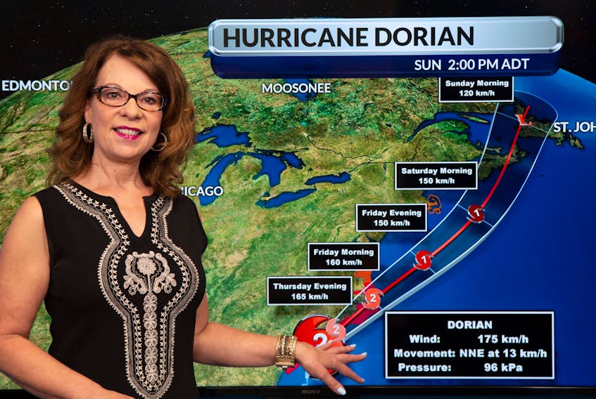
Dorian upgraded to a powerful Category 3 storm Thursday, off the U.S. eastern seaboard, but is expected to diminish to either a weak Category 1 or a strong tropical storm by the time it hits Nova Scotia around 8 or 9 p.m. Saturday. Nova Scotia is expected to bear the brunt of the storm’s wind, with gusts in some area reaching up to 110 km/h by late Saturday or early Sunday morning.
P.E.I. is expected to get both strong winds and heavy rain starting around 1 a.m. Sunday and lasting until about 7 a.m.
“P.E.I. is really going to get pounded with a lot of everything here,” noted SaltWire Network Chief Meteorologist Cindy Day.
Day said that starting early Sunday morning, P.E.I. is forecast to receive wind gusts of up to 100 km/h from the east for a few hours, which will then swing around and gust up to 100 km/h from the west.
The Island could also receive as much as 150-mm of rain, though Day said that somewhere in the area of a 130-mm is more likely.
The storm will be moving fast so it is not expected to linger over the Island and the weather should calm down by early afternoon Sunday.
HL: How Cindy Day sees Hurricane Dorian impacting Prince County, P.E.I.
“I would say the western third of the Island will see every bit as much rain, if not more, (than the rest of P.E.I.) So if Charlottetown is closer to 110-mm you could be around 130-mm.
“The wind won’t be quite as excessive because of the way the system is approaching. So you’ll see gusts of up to 80 km/h (from the east) and behind that gusts of up to 80 km/h from the west. But the rain will be quite significant.”
What’s Happening Now:
– A tropical cyclone information statement has been issued for Prince County by Environment Canada.
– Hurricane Dorian’s track into Atlantic Canada could still change depending on a number of variables, Islanders are encouraged to check local forecasts for updates.
– Islanders are encouraged to prepare and have on hand up to 72 hours of essential supplies.
– Pets should be kept indoors during severe weather and never leave a pet outside in a storm.
– The Government of P.E.I. is discouraging Islanders from going to the water to watch the storm as this could endanger both themselves and those who will try to save them.
– Any loose outdoor objects should be secured to reduce the risk of damage if they are carried away by the wind.
– Make a family emergency plan and prepare an emergency kit together.
[email protected]
www.facebook.com/JournalPMacLean
www.twitter.com/journalpmaclean