Maritimers can thank a Bermuda high for keeping Tropical Storm Isaias to the west of us, according to SaltWire Network's chief meteorologist Cindy Day.
“There's a big Bermuda high, it's a perennial system, and its position dictates where a tropical system will track,” Day said Tuesday afternoon. “If it's further off our coastline, it can come in between the Eastern Seaboard and the back side of the high. This time, the high is pretty close up to the East Coast, so it's steering the system to the west.
“At the same time, the clockwise flow around the high and the counterclockwise flow around the low are combining to pull in some very moist air across our region, so that's part of the reason for the continued heat warnings for southern New Brunswick, for all of P.E.I., for western regions of Nova Scotia and northwestern portions of the mainland, as well.”
That's going to continue until the trailing cold front pushes through Wednesday night to Thursday morning, bringing in a changing, dryer air mass behind it. Heat will start to build again for the weekend.
Day said some coastal areas of Nova Scotia could see some increased waves but not to a great degree.
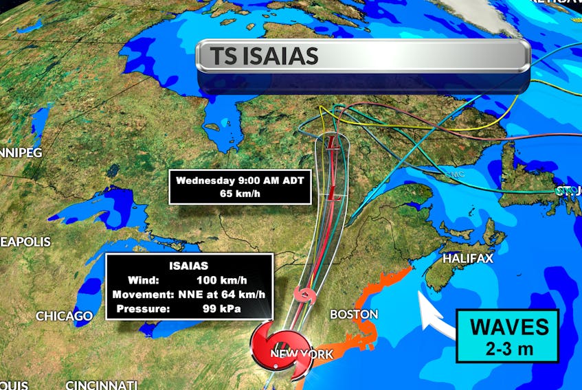
“If you were to find a little bit of sea swell and two- to three-metre waves, it would be along the South Shore and around the bend in towards the mouth of the Bay of Fundy,” she said.
Isaias, a name of Spanish origin meaning “God is my salvation,” made landfall Monday night along the North Carolina coast, Day said.
“For a brief time, the eye opened up again, so there was a nice, clear eye, but then that's closed and the system was downgraded from a Category 1 to a tropical storm, and that's where it sits right now. It's a fast-moving tropical storm that's in the process of transitioning to become extra-tropical. So at the time it starts to impact any weather in Ontario and Quebec, and a little bit in the western regions of the Maritimes, it will be extra-tropical. That just means the warm core has shifted, so instead of just being a closed cyclone, it becomes a low-pressure system with a warm front and a cold front, so that is going to bring changes to our weather as the warm front and the cold front attach to what's left to Isaias' push through.”
Rainfall warnings are in place for Quebec City, Ottawa and Montreal and significant rainfall is expected in western Maine.
“But for the Maritime provinces, 10 to 15 millimetres for northwestern New Brunswick and that's about all,” Day said.
Day said sea surface temperatures off Carolina are higher than average and should another storm develop, we could see some action, but the Bermuda high dictates everything.