SYDNEY, N.S. — Expect wet, windy and wavy weather for the next few days.
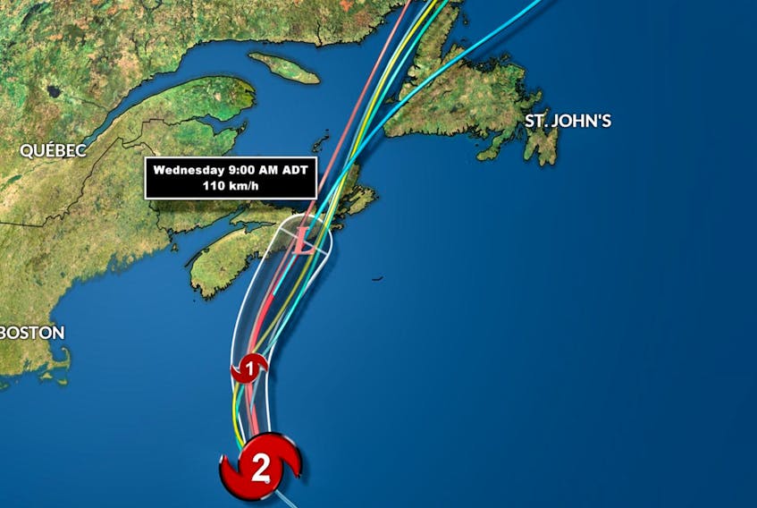
Chief SaltWire Network meteorologist Cindy Day said hurricane Teddy was racing toward Atlantic Canada with renewed intensity Tuesday after hitting the warmer waters of the Gulf Stream. And while the system is expected to be downgraded to a post-tropical storm by the time it makes landfall off Halifax on Wednesday morning, Cape Breton will still be battered by high winds, significant rainfall and storm surges.
“I would say your winds will hang on there until Thursday morning — you’ll have gusts of 50-60 (kilometres per hour) quite easily,” Day said during a news briefing Tuesday morning.
Day said the effects of Teddy were already apparent Tuesday as high winds began arriving 600 kilometres ahead of the eye of the storm and the cloud cover extended more than 1,500 kilometres across from Cape Cod to the Avalon Peninsula.
“The landfall is not expected until (Wednesday) morning but there’s a lot of weather ahead of the system,” she said.

The impending impact of the storm led school officials to send students home early Tuesday and officials in the Cape Breton Regional Municipality held their second news conference in as many days to update the public on their preparations.
Mayor Cecil Clarke said the CBRM will keep residents informed by posting updates to their social media pages and website.
He said because many trees still have their leaves, the winds and rain could create an umbrella-like effect that might result in more downed limbs, debris and power outages than similarly sized storms.
He also warned that Teddy could linger longer than some people expect.
“The other element of this is that we’ve been advised of is that there’s likely to be a pause and a second surge of weather, so citizens that look at this system thinking one system is passed, there’s likely a second system,” Clarke said.
“We ask again for the public’s patience and co-operation to stay away from coastal areas and our streets where emergency crews may need to respond.”
Along with preparing the CBRM fleet, securing loose objects municipal properties, clearing storm drains and trimming branches, CBRM’s emergency management office has been bracing for a worst-case scenario, Clarke said, encouraging people to follow provincial recommendations to have an emergency kit stocked with food, water, medicine on and other necessary supplies to last people and pets for at least 72 hours. In the event of flooding, homeowners are advised to unplug and elevate electronics in their basements. The CBRM also plans to monitor Nova Scotia Power’s outage reports to determine if comfort centres need to be opened.

CBRM solid-waste manager Francis Campbell said many people are heeding the municipality’s directive to remove or secure their heavy garbage from the ends of their driveways.
"We’ve had a good response from our residents in terms of the waste that’s out on the curb. A lot of it has been removed or secured down, and we’ve seen increased activity here on the (municipal landfill) site. People are actually taking the initiative to bring the material in themselves — be that heavy garbage or just the normal curbside collection,” he said, adding that while regular collection is still scheduled to go ahead in the coming days, anyone who doesn’t feel safe leaving their garbage or blue bags out can wait until next week.
“Residents have the option to hold onto the material if they don’t think they should put it out, and we’ll be making allowances next for any extra material that these people decide that they don’t want to put out.”
Nova Scotia Power mobilized more than 300 crews from across the region to respond to the storm, positioning people from Yarmouth to Cape Breton, including power-line technicians, forestry crews, planners, damage assessors, engineers, communication experts and customer-care representatives.

“With rain and wind forecasts anticipated to be above 80 kilometres for an extended period of time, we anticipate potentially two separate peaks of the storm, on Tuesday evening and through the day on Wednesday,” said Mark Sidebottom, chief operating officer. “Safety is our top priority and we want our customers to know we are ready to respond, as soon as it is safe to do so.”
Customers can report outages and get estimated restoration times online at outagemap.nspower.ca or by calling Nova Scotia Power at 1-877-428-6004. Estimated restoration times will be posted and updated as crews assess the damage.
With the exception of the western side of Cape Breton, most of the island can expect 60-70 millimetres of rain, said Day.
She said winds from the east would be gusting to 80-90 kilometres per hour by Tuesday evening before shifting direction to the southeast by midnight and dropping to 50-60 km/h. On Wednesday, however, the wind is expected to ramp back up midday, blowing 80-90 km/h until supper hour. Parts of western Cape Breton are also under a les suetes warning, with winds predicted to reach 110 km/h at times.
People living along south-facing shorelines should prepare for a significant storm surge, she said.
“I suspect that by about mid-morning (Wednesday) you’ll see waves crashing between seven and nine metres off the south coastlines.”